Giochi dell'Oca e di percorso
(by Luigi Ciompi & Adrian Seville)
(by Luigi Ciompi & Adrian Seville)
|
Giochi dell'Oca e di percorso
(by Luigi Ciompi & Adrian Seville) |
|
|
 |
Torna alla ricerca giochi (back to game search) |
 |
| New (A) Royal Geographical Pastime for England and Wales | ||
 |
Versione stampabile
 |
Invia una segnalazione

|
 |
primo autore: | Anonimo |
| secondo autore: | Sayer Robert | |
| anno: | 1787 | |
| luogo: |
Inghilterra-Londra |
|
| periodo: | XVIII secolo (4°/4) | |
| percorso: | Percorso di 169 caselle numerate | |
| materiale: | carta incollata su tela (engraving on paper with linen backing) | |
| dimensioni: | 553X680 | |
| stampa: | Litografia colorata a mano (hand-coloured engraving) | |
| luogo acquisto: | ||
| data acquisto: | ||
| dimensioni confezione: | ||
| numero caselle: | 169 | |
| categoria: | Geografia | |
| tipo di gioco: | Gioco di percorso | |
| editore: | Sayer Robert | |
| stampatore: | Sayer Robert | |
| proprietario: | Collezione L. Ciompi | |
| autore delle foto: | L. Ciompi (da "Goodfellow C.) | |
| numero di catalogo: | 1369 | |
| descrizione: |
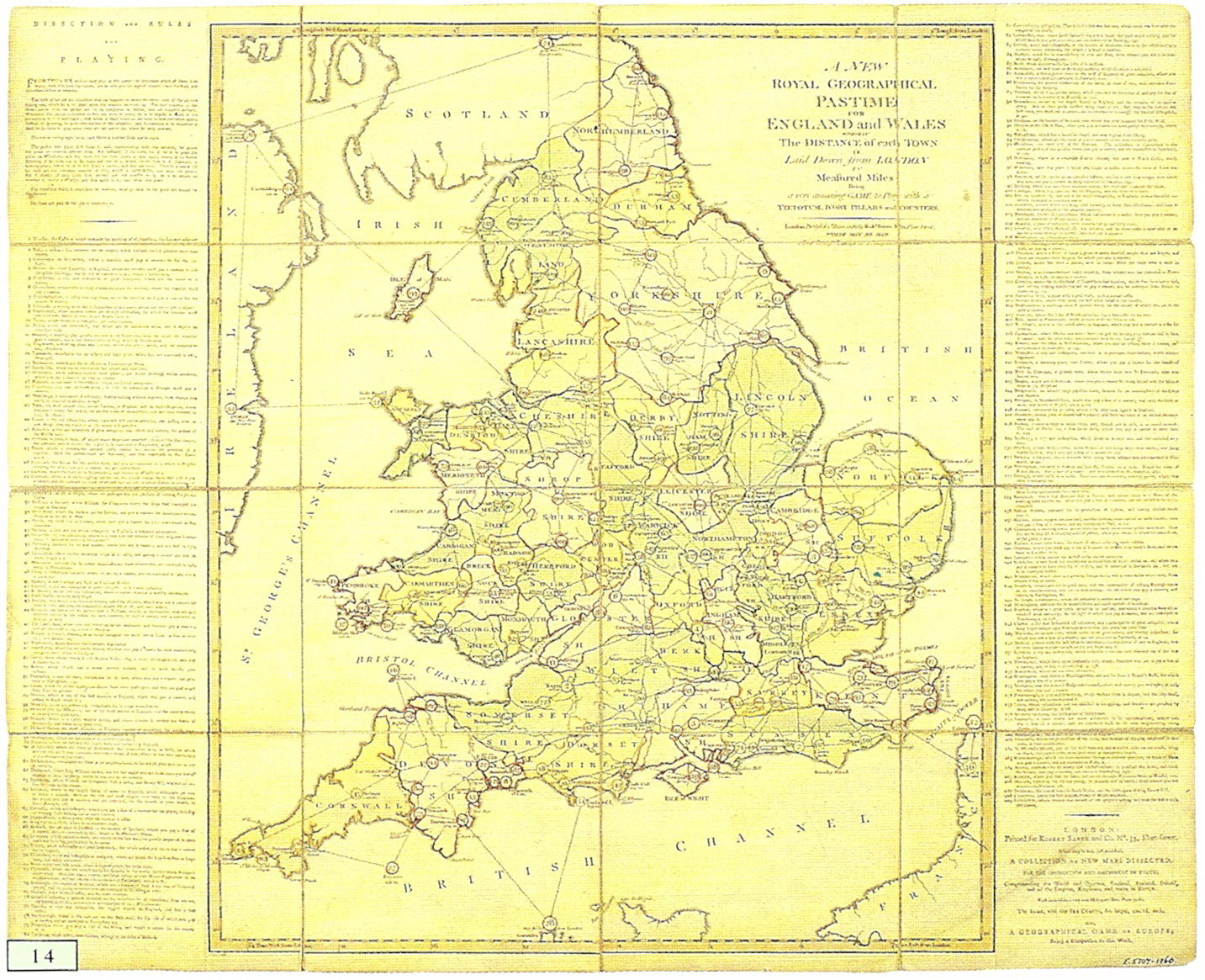
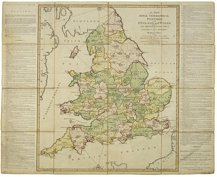
Gioco di 169 caselle distribuite sulla carta dell'Inghilterra. REGOLE: a destra e a sinistra sul tavoliere. CASELLE: mute. REFERENZA 1 "A New Royal Geographical Pastime for England and Wales". (V&A Museum). The title of this game, 'A New Royal Geographical Pastime for England and Wales' continues: 'Whereby the distanceof each town is laid down from London in measured miles being a very amusing game to play with a teetotum, ivory pillars and counters'. There are 169 principal and county towns joined by lines. The descriptions and rules on either side of the map list each town and any rewards or forfeits to be made. There are no charges for moving from one place to another. One of the better rewards occurs at Stonehenge 'worthy of visiting without expense, from whence you are to be removed to Chester at 148'. One of the harshest is at Knaresborough, 163, 'which has four medicinal springs of different qualities; to drink from them you must pay 1 counter and are conveyed to Bath, 2'. The game itself is enlightening , for it not only refers to visiting stately homes, cathedrals, churches and other public buildings but also describes events, folklore, and geographical features such as smuggling, the flitch of bacon given at Dunmow and the Giant's Causeway. Physical description Design: engraving, hand coloured, letterpress, 16 section mounted on linen CREED SCULP, lettered under map N°of squares: 169 Squares illustrated: none Square numbering: none Squares titled: all Subject of starting square: ? Subject of ending square: ? Place of Origin: London Date: 01/06/1787 Artist/maker: Robert Sayer Materials and Techniques: Hand-coloured engraved paper on linen Dimensions: Length: 55.3 cm; width: 68 cm Object history note: It shows a map of England and Wales with the rules and descriptions of some of the towns and cities pasted on either side. Robert Sayer was one of the leading publishers, producing both games and puzzles from 1754 to 1794 when his business was sold to Laurie & Whittle. Most games were in the form of maps, but he did produce one or two Goose games and the Game of the Snake. Historical context note Rewards: extra turns and moves Forfeits: loss of moves and turns and payment of counters N°of Players: any Equipment required: teetotum, ivory pillars (markers), counters Rules: There are 169 principal and county towns joined by lines. The descriptions and rules are on either side of the map and they list each town and any rewards or forfeits to be made. There are no charges for moving from one place to another. One of the better rewards occurs at Stonehenge `worthy of visiting without expense, from whence you are to be removed to Chester at 148'. One of the harshest is at Knaresborough, 163, `which has four medicinal springs of different qualities; to drink from them you must oay 1 counter and are conveyed to Bath, 2'. The game itself is enlightening , for it not only refers to visiting stately homes, cathedrals, churches and other public buildings but also describes events, folklore, and geographical features such as suggling, the flitch of bacon given at Dunmow and the Giant's Causeway. Rules placement: on either side of the map. Descriptive line: Hand coloured game, A New Royal Geographical Pastime for England and Wales published in England by Robert Sayer in 1787. REFERENZA 2 WHITEHOUSE, Francis Reginald Beaman, (pag. 8): ROYAL GEOGRAPHICAL PASTIME for England & Wales wherein The Distance of each Town is laid down from London in Measured Miles, being a very amusing game to Play with a Teetotum, Ivory Pillars and Counters. London. Published 12 May 1794 by Laurie & Whittle 53 Fleet Street, where may be had A TOUR THROUGH EUROPE as a Companion to This. An engraving of a map of England and Wales with the rules printed from type and affixed either side of the map, size in all 27 in X 21 ½ in, cut into 16 sections, mounted on canvas and hand-tinted in water colours. There are 169 named places: No 1 Windsor, 169 London. The numbers do not run consecutively from one adjoining town to the next, Bath being 2, 3 Cambridge, 4 Oxford, thus the children got to know the location of the town or they couldnt move their marker on to it. REFERENZA 3 "A New Royal Geographical Pastime for England and Wales (La Nouvelle géographie anglaise et galloise) fut édité en 1787 avec le sous-titre "Tracer la distance de chaque ville depuis Londres en miles est un jeu très amusant pratiqué avec un toton, des bornes et de jetons". Il s'agit d'une gravure en 16 sections colorées à la main et montées sur toile de lin, éditée par Robert Sayer le 1er juin 1787. On y trouve 169 villes principales et secondaires reliées entre elles par des traits, et de chaque coté on peut lire les règles, avec chaque ville répertoriée et succinctement décrite; on peut y lire aussi toutes les récompenses ou les pénalités à payer. Les récompenses prennent souvent la forme d'un nouveau tour de jeu, d'une avancée supplementaire, tandis que les pénalités obligent à passer son tour et à payer une ammende. Néanmoins, il ne coute rien de se déplacer d'un endroit à un autre. L'une des plus belles récompenses se trouve à Stonehenge, "site digne d'etre visité, d'où vous pouvez vous rendre à Chester en148". L'une des penalités les plus dures se trouve à Knaresborough, en 163, "qui présente quatre sources médicinales aux verts multiples, pour y boire, payez un jeton et partez ensuite pour Bath, en 2". Le jeu lui-meme est instructif, car il ne se contente pas de nous faire visiter des édifices publics, mais il décrit aussi des événements, le folklore et la géographie locale, comme par exemple la contrebande, ou la Chaussée des Géants." (GOODFELLOW Caroline) REFERENZA 4 "A New Royal Geographical Pastime for England and Wales was published in 1787 and bears the secondary title "Wherein the Distance of each Town is Laid Down from London in Measured Miles Being a very amusing Game to Play with a Teetotum, Ivory Pillars (markers) and Counters". The game is a hand-coloured engraving in 16 sections mounted on linen and it was published by Robert Sayer on June 1st,1787. There are 169 principal and county towns joined by lines, and on each side are the rules, listing each of the towns with a short description of it and any rewards to be received or forfeits to be paid. Rewards take the form of extra moves or turns, while the forfeits involve the loss of both moves and turn, and payments. However, there are no charges for moving from one place to another. One of the better rewards occurs at Stonehenge "worthy of visiting without expense, from whence you are to be removed to Chester at 148." One of the harshest is at Knaresborough, 163, "which has four medicinal springs of different qualities; to drink from them you pay 1 counter and are conveyed to Bath 2". The game itself is enlightening, for it not only refers to visiting stately homes, cathedrals, churches and other public buildings but also describes events, folklore and geographical features such as smuggling, the flitch of bacon given at Dunmow and the Giant's Causeway." (GOODFELLOW Caroline) REFERENZA 4 ROYAL GEOGRAPHICAL PASTIME for England & Wales wherein The Distance of each Town is laid down from London in Measured Miles, being a very amusing game to Play with a Teetotum, Ivory Pillars and Counters. London. Published 12 May 1794 by Laurie & Whittle 53 Fleet Street, where may be had A TOUR THROUGH EUROPE as a Companion to This. An engraving of a map of England and Wales with the rules printed from type and affixed either side of the map, size in all 27 in X 21 ½ in, cut into 16 sections, mounted on canvas and hand-tinted in water colours. There are 169 named places: No 1 Windsor, 169 London. The numbers do not run consecutively from one adjoining town to the next, Bath being 2, 3 Cambridge, 4 Oxford, thus the children got to know the location of the town or they couldnt move their marker on to it. |
|
| bibliografia: |
1) WHITEHAUSE, F.R.B.: "Table Games of Georgian and Victorian Days", London, Peter Garnett, 1951. 2) GOODFELLOW, Caroline: "A Collector's Guide to Games and Puzzles". Secaucus, New Jersey, Chartwell Books-London, Quintet Publishing Limited 1991. 3) GOODFELLOW, Caroline: "The Development of the English Board Game, 1770-1850", in Board Games Studies 1, 1998. 4) GOODFELLOW, Caroline: "Jeux de société. Le guide du collectionneur des jeux de société depuis le XVIIIe siècle jusquà nos jours", (Edizione francese) Carrousel MS, 2001. 5) SEVILLE, Adrian: "The Game of Goose: and its influence on cartographical race games" Journal of the International Map Collectors' Society, Winter 2008 N°115 2008. 6) SEVILLE, Adrian: "The geographical Jeux de l'Oie of Europe." In "Belgeo" 2008 3-4 2008. 7) GOODFELLOW, Caroline: "How We Played: Games From Childhood Past", History Press, 2012. 8) QUINN, Brian - CARTWRIGHT, William: "Geographic Board Games". Geospatial Science Research 3. School of Mathematical and Geospatial Science, RMIT University, Australia. December 2014. 9) SEVILLE, Adrian: "The Royal Game of the Goose four hundred years of printed Board Games". Catalogue of an Exhibition at the Grolier Club, February 23 - May 14, 2016. 10) LIMAN, Ellen: "Georgian and Victorian Board Games: The Liman Collection", Pointed Leaf Press, 2017. 11) NORCIA, Megan A.: "Gaming Empire in Children's British Board Games, 1836-1860". Studies in Childhood, 1700 to the Present. Routledge, 2019. 12) SEVILLE, Adrian: "L'arte dei giochi da tavolo. Oltre un secolo di storia e divertimento dalla fine del Settecento all'inizio del Novecento." Edizioni White Star, 2019. 13) PARLAK, Omer Fatih: "Seafearing through the Perspective of Historic Board Games", in DGSM, Köllen Druck+Verlag, Bonn 2020. |
|
| "The Development of the English Board Game, 1770-1850" (Caroline G. Goodfellow) | ||
| Geographical Games. "Table Games of Georgian and Victorian Days". (Francis Reginald Beaman, Whitehause) | ||
Vai alla ricerca giochi Vai all'elenco autori