Giochi dell'Oca e di percorso
(by Luigi Ciompi & Adrian Seville)
(by Luigi Ciompi & Adrian Seville)
|
Giochi dell'Oca e di percorso
(by Luigi Ciompi & Adrian Seville) |
|
|
 |
Torna alla ricerca giochi (back to game search) |
 |
| Royal Geographical Amusement or the Safe and Expeditious Traveller through all the Parts of Europe by Sea and by Land. | ||
| An Instructive Game Calculated for the Improvement of the Young Learners of Geography by Dr. Journey | ||
 |
Versione stampabile
 |
Invia una segnalazione

|
     |
primo autore: | Journey Dr. |
| secondo autore: | Laurie Richard Holmes (Sayer Robert) | |
| anno: | 1813 | |
| luogo: |
Inghilterra-Londra |
|
| periodo: | XVIII secolo (3°/4) | |
| percorso: | Percorso di 103 caselle numerate | |
| materiale: | carta (paper) (papier) | |
| dimensioni: | 505X534 | |
| stampa: | Litografia (gravure) (engraving) | |
| luogo acquisto: | ||
| data acquisto: | ||
| dimensioni confezione: | ||
| numero caselle: | 103 | |
| categoria: | Geografia | |
| tipo di gioco: | Gioco di percorso | |
| editore: | Laurie Richard Holmes (Sayer Robert) | |
| stampatore: | Laurie Richard Holmes (Sayer Robert) | |
| proprietario: | Collezione L. Ciompi | |
| autore delle foto: | L. Ciompi (da "Goodfellow C.) | |
| numero di catalogo: | 1370 | |
| descrizione: |
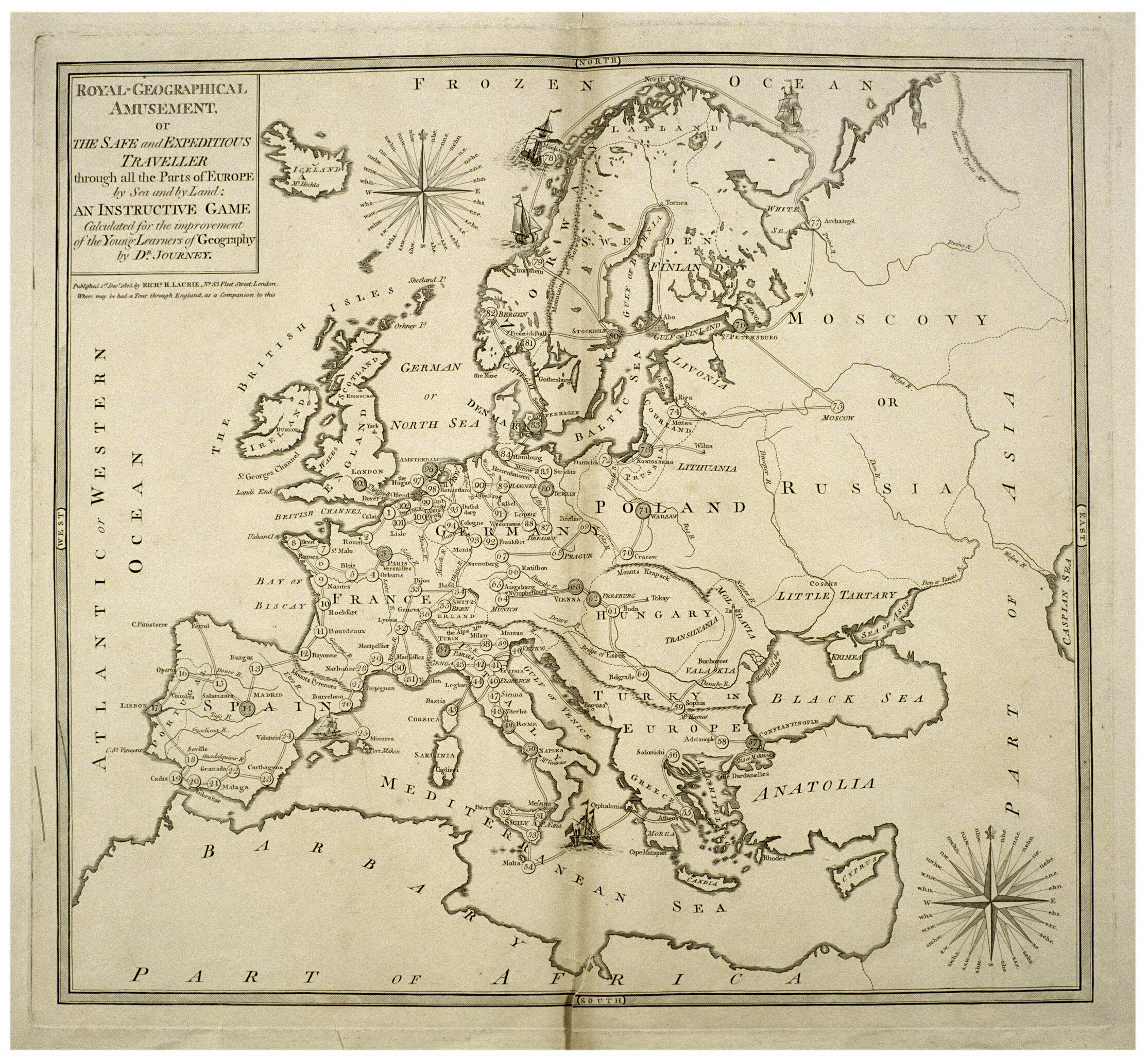
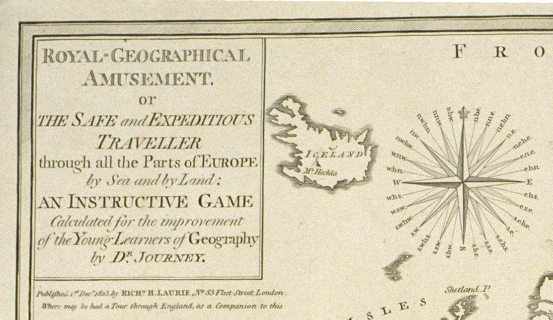
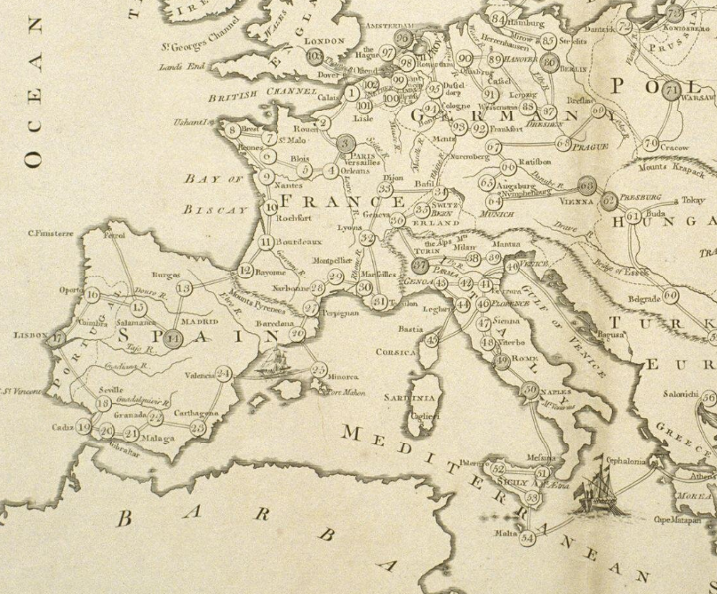
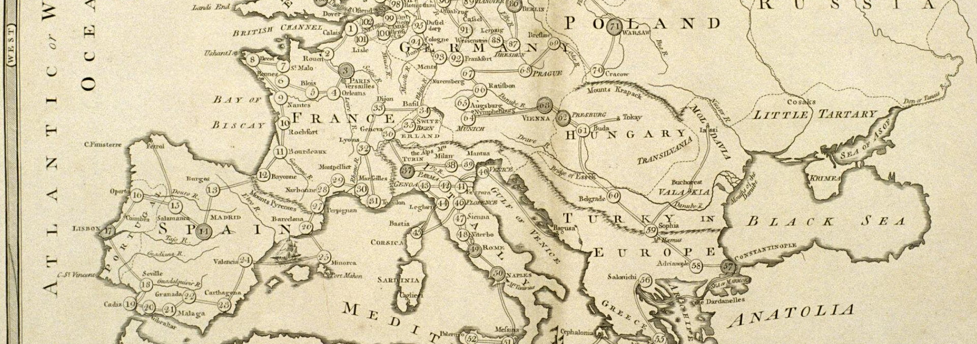
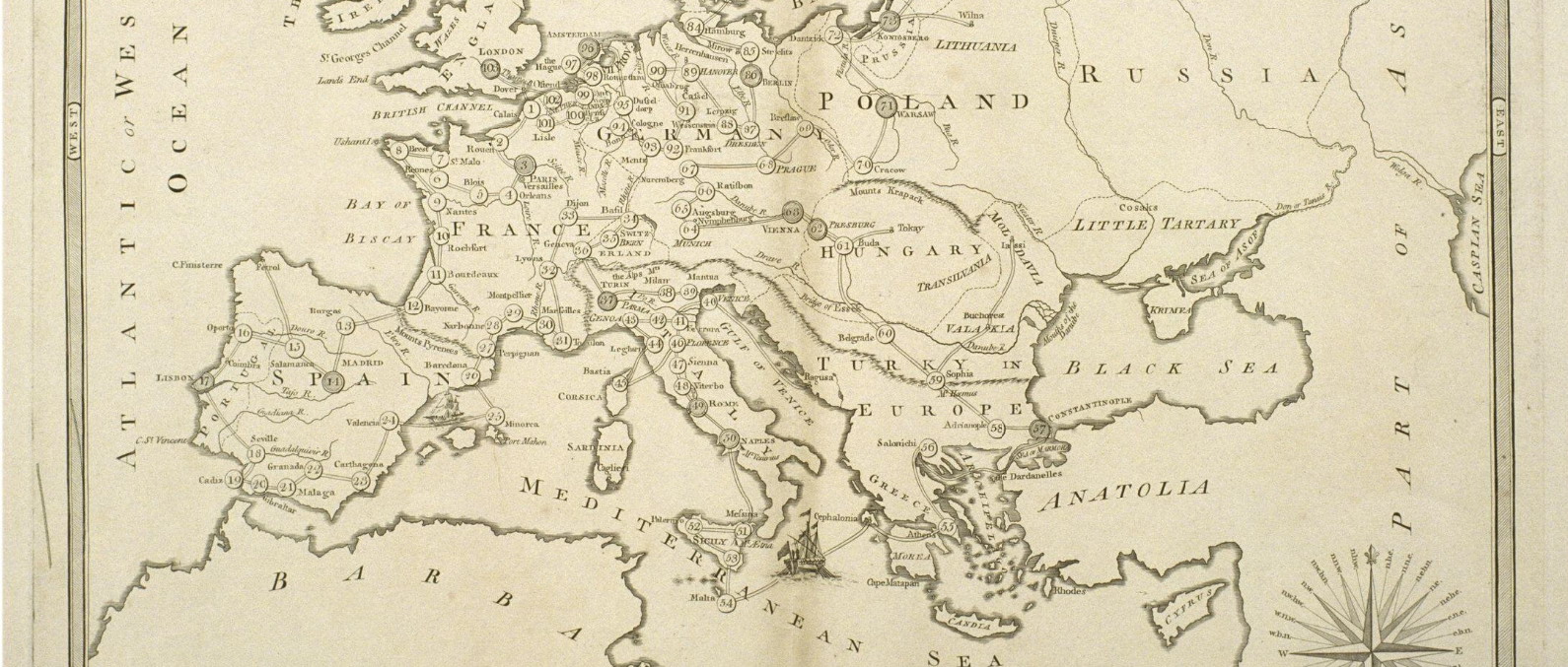
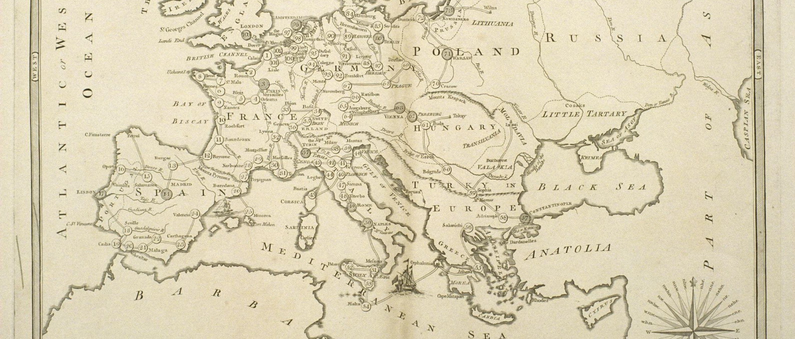
Gioco di 103 caselle numerate distribuite sulla carta dell'Europa. REGOLE: non riportate sul tavoliere. CASELLE: mute. NOTA: Vedi analogo gioco (arch. n°1345). REFERENZA 1 "Royal Geographical Amusement or the Safe and Expeditious Traveller through all the Parts of Europe by Sea and by Land." (V&A Museum) This European-centred game was originally a companion to 'A New Royal Geographical Pastime for England and Wales' and is subtitled an 'Instructive Game Calculated for the Improvement of the Young Learner of Geography by Dr Journey'. It was originally published by Robert Sayer in 1774. Laurie and Whittle succeeded Sayer in 1794 and were in turn succeeded by R. H. Laurie in 1813. It would appear that the game is an impression from the original plate with the lettering altered. Physical description Design: engraving; impression from the plate used for printing the playing sheet showing a map of Europe with the principal and capital cities numbered, together with printed sheet of rules and descriptive text. N°of squares: 103 Squares illustrated: ? Square numbering: 1 to 103 Squares titled: in text Subject of starting square: Calais Subject of ending square: London Place of Origin: London Date: 01/12/1823 Artist/maker: R. H. Laurie Materials and Techniques: Engraved paper Dimensions: Length: 50.5 cm; width: 53.4 cm Object history note: The game was published by Robert Sayer in 1774. Robert Laurie and James Whittle succeeded Sayer at his premises in 1794 and were in turn succeeded by R. H. Laurie in 1813 (1813-59). It would appear that the game is an impression from the original with the lettering altered. See details after the rules. The game was originally a companion to A New Royal Geographical Pastime for England and Wales. Historical context note Rewards: forward movement and extra turns Forfeits: backward movement and missing turns N°of Players: 2 to 6 Equipment required: teetotum; turned pillars called Travellers with four counters matching each of the Travellers Rules: EXPLANATION AND RULES OF THE GAME The number of players may be from two to six; he who has the highest number in spinning the totum, is to begin, and the others are to follow according to their respective numbers. Three Gentlemen or Ladies are supplied to make the tour of Europe; they are represented by the three Turned Pillars, called Travellers, each of the players having one of these, which is to be placed at the stage corresponding to the number turned up. the four counters, of the same colour with the Traveller, are to be employed as Markers, and take the name SERVANTS. The player is to lay down as many of these as he is ordered to wait turns, and when it comes to his turn to spin again, instead of spinning he must take up one Marker, and so on, till they are all taken up. The person who plays first, places his Traveller according to the number given by the totum, for instance, if you turn up No. 7, you place the turned Pillar upon St. Malo, and there let it remain until it is you turn to spin again; at the second spinning you turn up No. 4, let it be added to 7, which being 11, you proceed on your journey in removing the Traveller to Bordeaux, and so on till you arrive at London, No. 103, which is the end of the Game and the Journey. But as it may very often happen that the Traveller should be carried beyond this last number, by the chances of play, in such a case he is to return to Hanover at 89 and then spin again his turn, to take his departure from that town. The Traveller, which is overtaken by another, must go back to the stage left vacant by the former. The rules are followed by a descriptive passage for each of the 103 stages. This also gives any forfeits and rewards At the bottom of the rules and explanation is the following text: LONDON: Printed for Robert Sayer and Co., Fleet Street. Where may be had just published A collection of new maps dissected for the instruction and amusement of youth, comprehending the world and the quarters, England, Scotland, Ireland and all the Empires, Kingdoms and States in Europe. Each enclosed in a very neat mahogany box. Price 7s. 6d. The same, with the sea coasts, etc, larger 10s 6d. each. Also a new Geographical Game of England and Wales; with an excursion to France, Scotland and Ireland, being a companion to this. Rules placement: printed sheet with descriptive text of each stop Descriptive line: Engraved paper game, Royal Geographical Amusement, published in England by R. H. Laurie in 1823 REFERENZA 2 WHITEHOUSE, Francis Reginald Beaman, (pag. 7-8): ROYAL GEOGRAPHICAL AMUSEMENT or the Safe and Expeditious Traveller through all the Parts of Europe by Sea and by Land. An Instructive Game Calculated for the improvement of the Young Learners of Geography by DR. JOURNEY. London. Printed for Robt. Sayer, Map arid Printseller at No 53 in Fleet Street as the Act directs 10 Jany 1774. Price 55s. Completely done upon a Past Board with Box, Totum, Pillars and Counters Included. An engraving of the map of Europe with explanation and rules printed from type and affixed either side the map, size in all 28 ½ in X 19 ½ in, hand-coloured, cut into 16 sections, mounted on white canvas and contained in slip case without label. Starting at Calais, No 1 the players tour Europe and finish at 103 London, staying the stated number of turns at most of the cities or in the case of 41 Ferrara, a decayed and very unwholesome city in the Popes dominions, go back to 29 Montpellier to breathe the pure air of that city. No 89 Hanover is the Capital of His Majestys (Geo. III) German dominions. REFERENZA 3 Royal Geographical Amusement of the safe and expeditious Traveller Through all the Parts of Europe by Sea and by Land (Divertissement géographique du voyageur à travers l'Europe par mer et par terre), est une gravure colorée à la main, éditée par Richard Holmes Laurie le 1er décembre 1823. Ce jeu, à l'origine, allait de paire avec "La nouvelle géographie anglaise et galloise, de Robert Sayer et les règles portaient d'ailleur toujours le nom de celui-ci. Le sous-titre de ce jeu en révèle le véritable objectif: "Un jeu instructif conçu pour l'édification des jeunes élèves en géographie par le Dr. Journey." (GOODFELLOW Caroline) REFERENZA 4 "Royal Geographical Amusement of the safe and expeditious Traveller Through all the Parts of Europe by Sea and by Land", a hand-coloured engraving, was published by Richard Holmes Laurie on December 1, 1823. This game was originally a companion to "A New Royal Geographical Pastime for England and Wales", which was published by Robert Sayer, and its sheet of rules still bears Sayer's name. The secondary title of this game reveals the true purpose for which it was designed: "An instructive Game Calculated for the Improvement of the Young Learners of Geography by Dr. Journey". (GOODFELLOW Caroline) |
|
| bibliografia: |
1) WHITEHAUSE, F.R.B.: "Table Games of Georgian and Victorian Days", London, Peter Garnett, 1951. 2) GOODFELLOW, Caroline: "A Collector's Guide to Games and Puzzles". Secaucus, New Jersey, Chartwell Books-London, Quintet Publishing Limited 1991. 3) GOODFELLOW, Caroline: "The Development of the English Board Game, 1770-1850", in Board Games Studies 1, 1998. 4) GOODFELLOW, Caroline: "Jeux de société. Le guide du collectionneur des jeux de société depuis le XVIIIe siècle jusquà nos jours", (Edizione francese) Carrousel MS, 2001. 5) SEVILLE, Adrian: "The Game of Goose: and its influence on cartographical race games" Journal of the International Map Collectors' Society, Winter 2008 N°115 2008. 6) SEVILLE, Adrian: "The geographical Jeux de l'Oie of Europe." In "Belgeo" 2008 3-4 2008. 7) GOODFELLOW, Caroline: "How We Played: Games From Childhood Past", History Press, 2012. 8) QUINN, Brian - CARTWRIGHT, William: "Geographic Board Games". Geospatial Science Research 3. School of Mathematical and Geospatial Science, RMIT University, Australia. December 2014. 9) SEVILLE, Adrian: "The Royal Game of the Goose four hundred years of printed Board Games". Catalogue of an Exhibition at the Grolier Club, February 23 - May 14, 2016. 10) LIMAN, Ellen: "Georgian and Victorian Board Games: The Liman Collection", Pointed Leaf Press, 2017. 11) NORCIA, Megan A.: "Gaming Empire in Children's British Board Games, 1836-1860". Studies in Childhood, 1700 to the Present. Routledge, 2019. 12) SEVILLE, Adrian: "L'arte dei giochi da tavolo. Oltre un secolo di storia e divertimento dalla fine del Settecento all'inizio del Novecento." Edizioni White Star, 2019. 13) PARLAK, Omer Fatih: "Seafearing through the Perspective of Historic Board Games", in DGSM, Köllen Druck+Verlag, Bonn 2020. |
|
| "The Development of the English Board Game, 1770-1850" (Caroline G. Goodfellow) | ||
| Geographical Games. "Table Games of Georgian and Victorian Days". (Francis Reginald Beaman, Whitehause) | ||
Vai alla ricerca giochi Vai all'elenco autori